Press release
Maps101 announces new interactive learning environment using Bing Maps.
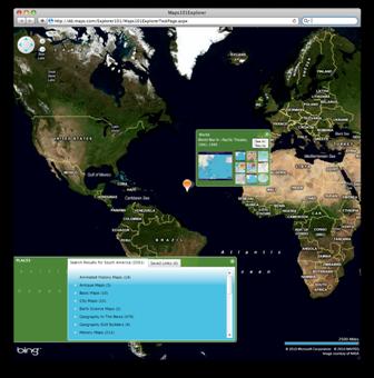
Users of the online K-12 resource will now be able to explore streets, neighborhoods, cities and countries, search for relevant content and share their experiences as part of a host of exciting new Maps101 features developed with Bing.
For the initial launch, subscribers can use the dynamic map to find Maps101 content – including National Geographic videos, Maps, Lesson plans and Educational games and activities – for a specific geographic location.
Students can also take ‘virtual field trips’ – for example touring Maps101’s ‘Monuments of Washington DC’ map in 3-D or at street level view.
Bing Maps includes bird’s eye views and stunning aerial and satellite imagery, and enables users to zoom down progressively closer for more detail, or use wide angled map views to illustrate broader concepts.
“Bing Maps will help teachers communicate complex issues in a geographic context, using stunning imagery and an immersive mapping experience, “ according to John Serpa, CEO of Maps101.
“From the Science Teacher comparing regional climates to the History Teacher illustrating the progression of the civil war, Bing adds yet another Maps101 facet that will engage students.”
Because Bing maps is a browser based tool, schools and individuals do not need to download and run a separate application in order to use the new feature (although a browser plug-in is necessary for 3-D viewing).
“First and foremost Maps101 is about content. Bing offers a unique way of presenting great support materials in a way that will capture the imagination of students, and help them retain information,” Serpa continued.
Bing Maps incorporates a host of exciting features, which Maps101 developers hope to bring to classrooms, including Photosynth, where user-compiled photos of a location are used to create a 3-dimensional view, and a recently unveiled augmented reality feature allowing map users to zoom in from street level, for a live, interactive view of a location. The ability to share content and experiences with other users will also introduce a social aspect to the Maps101 environment.
“We are delighted to be working with Maps101 in the development of a true 21st-century learning tool that has the potential to change the way students learn about their world,” said Eric Waldman, Bing Maps Geospatial Specialist
# # #
About Maps101:
Maps101 is an online, subscription based resource for multiple subjects. Content includes maps, videos, lesson plans, educational games, atlases for use in History, Earth Science, Geography, Languages and more. Teachers, Students and Parents of subscriber schools receive unlimited access from any internet connected computer. Maps101 was formed in 1998 as a division of Maps.com
Maps101
120 Cremona Drive Suite H
Santa Barbara CA, 93109
Stephanie Jensen
This release was published on openPR.
Permanent link to this press release:
Copy
Please set a link in the press area of your homepage to this press release on openPR. openPR disclaims liability for any content contained in this release.
You can edit or delete your press release Maps101 announces new interactive learning environment using Bing Maps. here
News-ID: 127492 • Views: …
More Releases for Maps
Cloud GIS Market Analysis and Forecast to 2025 by Key Players CartoDB, ESRI, GIS …
Global Cloud GIS Market”. It aims to deliver a clear understanding of the industry which has been examined by using primary and secondary research methodologies of proven nature. It underlines different dynamics of businesses such as client requirements, products or services, demand factor, shares, and raw material. In addition, it further utilizes an effective analysis technique such as, SWOT and Porter’s Five analysis which helps to elaborate strengths, weaknesses, threats,…
Cloud GIS Market Rising Demand by Key Players Google Maps (Google), Bing Maps (M …
How technological advancements is changing the dynamics of Global Cloud GIS market. Know more about the key market trends and drivers in latest broadcast about Cloud GIS market from HTF MI.
HTF MI published a new industry research that focuses on Cloud GIS market and delivers in-depth market analysis and future prospects of Global Cloud GIS market. The study covers significant data which makes the research document a handy resource for…
Global Cloud GIS Market 2017: SuperMap, GeoStar, Google Maps (Google), Bing Maps …
Global Cloud GIS Market Report 2017-2022
Industry research report that focuses on Cloud GIS Market and provides in-depth Global Cloud GIS market analysis and future prospects of Cloud GIS market 2017-2022 analyses the crucial factors of the Cloud GIS market based on current industry conditions, market trends & demands, business methods embraced by Cloud GIS market contenders and their growth scenario. This report also provides in-depth data of Cloud GIS…
Cloud GIS Market- ESRI, Google Maps (Google), Bing Maps (Microsoft), SuperMap, Z …
Global Cloud GIS Market Size, Status and Forecast 2022 provides Market information about Manufacturers, Countries, Type and Application.This Industry report also states Company Profile, sales, Cloud GIS Market revenue and price, market share, market growth and gross margin by regions.
Top Manufacturers/Key Players:-
ESRI
Google Maps (Google)
Bing Maps (Microsoft)
SuperMap
Zondy Crber
…
Technology Advancement- Europe Cloud GIS Market Size, Shares, Growth Rate, Forec …
The report analyzes and presents an overview on "Europe Cloud GIS Market Report 2016" worldwide.
Sales, means the sales volume of Cloud GIS
Revenue, means the sales value of Cloud GIS
This report studies sales (consumption) of Cloud GIS in Europe market, especially in Germany, UK, France, Russia, Italy, Benelux and Spain, focuses on top players in these countries, with sales, price, revenue and market share for each player in these Countries, covering
CartoDB
ESRI
Hexagon
GIS…
Boston Rare Maps Features Civil War Maps and Ephemera
SOUTHAMPTON, MA – Boston Rare Maps, one of the country’s premier specialists in rare and unusual antique maps, presents a unique selection of original maps and ephemera from the American Civil War. Included is an iconic 1864 Currier & Ives political cartoon, a schematic map detailing the battle of Gettysburg and a handwritten report by a South Carolina general assessing the tactical situation in Charleston Harbor before the bombardment…